HacDC Spaceblimp 5: Difference between revisions
From HacDC Wiki
Hexagon5un (talk | contribs) |
No edit summary |
||
| (14 intermediate revisions by 3 users not shown) | |||
| Line 1: | Line 1: | ||
[[Image: sb5_IMG_9220.JPG | 500 px]] | [[Image: sb5_IMG_9220.JPG | 500 px]] | ||
| Line 7: | Line 5: | ||
== Summary == | == Summary == | ||
This time we were going for altitude | This time we were going for altitude, and we got it! The max recorded altitude was 118,533 ft! (Getting us the 16th highest altitude record on [[http://arhab.org/ ARHAB.org]] !) | ||
The launch site was: Strasburg VA, in a open area near the town on Rt 11, near the I-81. | The launch site was: Strasburg VA, in a open area near the town on Rt 11, near the I-81. | ||
| Line 14: | Line 11: | ||
Lon: 78.3508W | Lon: 78.3508W | ||
[[Image: sb5_launch_still.jpg | 500 px]] | [[Image: sb5_launch_still.jpg | 320 px]] [[Image: sb5_track.jpg | 500 px]] | ||
The path the balloon took was pretty strange, with the wind shifting between ascent and descent, and so we had a lot more driving to do than usual. The primary GPS/radio worked perfectly, and we got super-lucky with the recovery, picking up the package ~15 minutes after it hit the ground. The video camera overheated and failed before launch (booo!) and we're still working on the instrument data, but all signs point to some new and interesting results at the highest altitude we've ever run. | |||
What challenges are left for the Spaceblimp project? Get involved: subscribe to [[http://hacdc.org/mailman/listinfo/spaceblimp the Spaceblimp mailing list]] and help us figure it out! | |||
Visiting from another planet? [http://www.hacdc.org/about Here's more about us]. | |||
Want to help us do more awesome stuff? [http://www.hacdc.org/donate Make a tax deductible donation to our .org!] | |||
and | == Pictures and Video == | ||
Photos have been uploaded to http://www.flickr.com/photos/itechgeek/sets/72157627058450849/. | |||
== Data == | == Data == | ||
| Line 46: | Line 29: | ||
=== Accelerometer === | === Accelerometer === | ||
For now, here is the raw accelerometer data: [Media: spaceblimp5_accelerometer.csv.gz] | For now, here is the raw accelerometer data: [[Media: spaceblimp5_accelerometer.csv.gz]] | ||
Analysis to come in the next few days.... | Analysis to come in the next few days.... | ||
| Line 87: | Line 70: | ||
| 9 DOF IMU, Geiger counter, temperature, pressure, humidity, and light sensors | | 9 DOF IMU, Geiger counter, temperature, pressure, humidity, and light sensors | ||
|} | |} | ||
== Payload == | |||
=== Radios === | |||
There were two radios on board the blimp that transmitted out the GPS data: | |||
* The primary radio was tied to the GPS and transmitted out to a network of amateur radio enthusiasts who then passed the location information on to get mapped here: [http://aprs.fi/?call=W3HAC-11 APRS.fi]. We also ran some custom software that passes this data on to a Twitter account (once per minute!) which you could follow on your phone: [http://twitter.com/#!/DCSpaceblimp DC Spaceblimp Primary Twitter Feed]. (Click the link in the Twitter to pull up a map!) | |||
* The secondary radio was actually a GSM cell phone module, and broadcasted its data when in range of a cell tower. It broadcasted both GPS data for tracking, and a lot of the sensor data for science. It also twittered through [http://twitter.com/#!/SocietyofRobotz Society Of Robots Twitter Feed]. | |||
=== Cameras === | |||
The payload contains a couple cameras: | |||
* a video camera (Canon Zi6) | |||
* a still camera (Canon Powershot A-480) running custom firmware to get better exposures from space | |||
=== Instrumentation === | |||
and a lot of instrumentation: | |||
* a geiger counter | |||
* 9 degree-of-freedom IMU ([http://en.wikipedia.org/wiki/Inertial_measurement_unit Inertial Measurement Unit on Wikipedia]) | |||
* high-speed (50 sample/sec) accelerometer | |||
* internal and external temperature sensors | |||
* humidity sensor | |||
* air pressure sensor | |||
* IR and visible light sensors | |||
* a solar panel, hooked up to measure the voltage | |||
{{Template:Spaceblimp}} | {{Template:Spaceblimp}} | ||
Latest revision as of 07:57, 3 April 2012
Spaceblimp-5 Launched: July 9, 2011
Summary
This time we were going for altitude, and we got it! The max recorded altitude was 118,533 ft! (Getting us the 16th highest altitude record on [ARHAB.org] !)
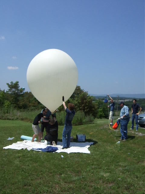
The launch site was: Strasburg VA, in a open area near the town on Rt 11, near the I-81. Lat: 38.9968 N Lon: 78.3508W
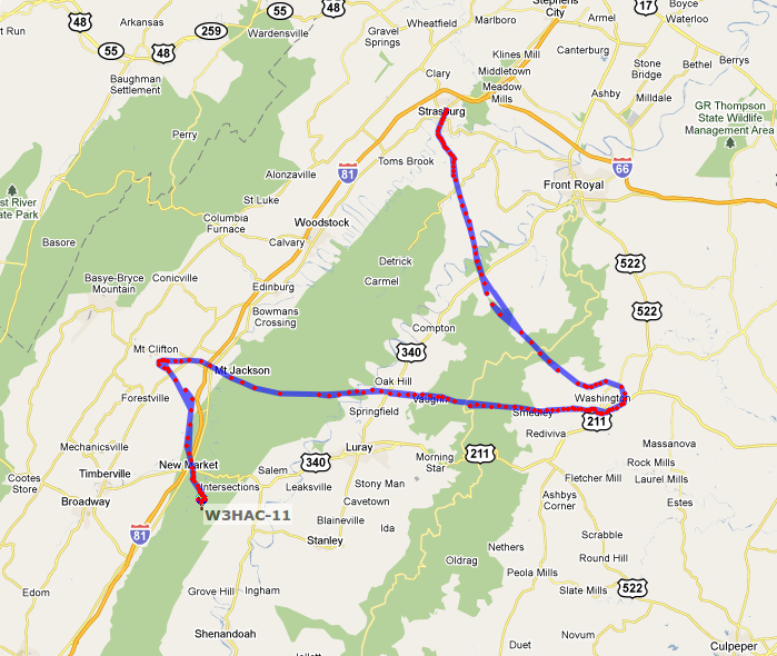
The path the balloon took was pretty strange, with the wind shifting between ascent and descent, and so we had a lot more driving to do than usual. The primary GPS/radio worked perfectly, and we got super-lucky with the recovery, picking up the package ~15 minutes after it hit the ground. The video camera overheated and failed before launch (booo!) and we're still working on the instrument data, but all signs point to some new and interesting results at the highest altitude we've ever run.
What challenges are left for the Spaceblimp project? Get involved: subscribe to [the Spaceblimp mailing list] and help us figure it out!
Visiting from another planet? Here's more about us.
Want to help us do more awesome stuff? Make a tax deductible donation to our .org!
Pictures and Video
Photos have been uploaded to http://www.flickr.com/photos/itechgeek/sets/72157627058450849/.
Data
Accelerometer
For now, here is the raw accelerometer data: Media: spaceblimp5_accelerometer.csv.gz
Analysis to come in the next few days....
Flight Tracker
Launch Plans
| Planned launch date: | Saturday, July 9, 2011 |
|---|---|
| Launch time: | 10:00 AM, Launch should take less than an hour. |
| Launch Location: |
Strasburg, VA |
| Coordination/Talk-in: | 146.685 MHz simplex (this might change, please monitor Twitter (@HacDCSpaceblimp) and mailing list for updates. |
| Planned Altitude: | 120,000 Feet |
| Planned Ascent Rate: | 1,000 feet/minute |
| Planned Descent Rate: | 1,000 feet/minute |
| Primary Beacon: | Son-of-WhereAVR with ublox GPS. Yaesu VX-1 handi-talkie with 1 W Transmitter, call sign W3HAC-11 (map), Frequency 144.390 MHz |
| Secondary Beacon: | GSM mobile phone modue, uBlox GPS |
| Payload: | 9 DOF IMU, Geiger counter, temperature, pressure, humidity, and light sensors |
Payload
Radios
There were two radios on board the blimp that transmitted out the GPS data:
- The primary radio was tied to the GPS and transmitted out to a network of amateur radio enthusiasts who then passed the location information on to get mapped here: APRS.fi. We also ran some custom software that passes this data on to a Twitter account (once per minute!) which you could follow on your phone: DC Spaceblimp Primary Twitter Feed. (Click the link in the Twitter to pull up a map!)
- The secondary radio was actually a GSM cell phone module, and broadcasted its data when in range of a cell tower. It broadcasted both GPS data for tracking, and a lot of the sensor data for science. It also twittered through Society Of Robots Twitter Feed.
Cameras
The payload contains a couple cameras:
- a video camera (Canon Zi6)
- a still camera (Canon Powershot A-480) running custom firmware to get better exposures from space
Instrumentation
and a lot of instrumentation:
- a geiger counter
- 9 degree-of-freedom IMU (Inertial Measurement Unit on Wikipedia)
- high-speed (50 sample/sec) accelerometer
- internal and external temperature sensors
- humidity sensor
- air pressure sensor
- IR and visible light sensors
- a solar panel, hooked up to measure the voltage
| [email protected] |
| Subscribe to the Spaceblimp email list |


