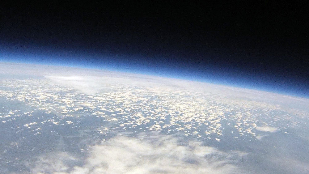
HacDC Spaceblimp 7: Difference between revisions
From HacDC Wiki
m (added spaceblimp template at bottom of page) |
(→Project Description & Status: nnnn) |
||
| (17 intermediate revisions by 4 users not shown) | |||
| Line 1: | Line 1: | ||
[[Image: Sb7_peak.jpg | 800px ]] | |||
=Flight Summary= | |||
[[Image: Sb7_flight_path.jpg | 750px ]] | |||
{| {{Prettytable|width=557px}} | |||
!align="right"| Date of launch: | |||
| Saturday, April 14, 2018 | |||
|- | |||
!align="right"| Time of launch: | |||
| 11:08 | |||
|- | |||
!align="right"| Time of landing: | |||
| 14:30 | |||
|- | |||
!align="right"| Time of recovery: | |||
| ~17:15 | |||
|- | |||
!align="right"| Flight duration: | |||
| 3:22:00 | |||
|- | |||
!align="right"| Peak recorded altitude: | |||
| TBD | |||
|- | |||
!align="right"| Location of launch: | |||
| Strasburg VA, (38 59'48.77"N 78 21'03.27"W) | |||
|- | |||
!align="right"| Location of landing: | |||
| Manchester MD, (39 40'33.6"N 76 44'03.9"W) | |||
|- | |||
!align="right"| Distance (launch to landing): | |||
| 98.3 mi, (158.2 km) | |||
|- | |||
!align="right"| Balloon type: | |||
| 1500 g Kaymont | |||
|- | |||
!align="right"| Payload weight: | |||
| TBD | |||
|- | |||
!align="right"| Balloon lift: | |||
| TBD | |||
|- | |||
!align="right"| Net lift: | |||
| TBD | |||
|} | |||
---- | |||
=Project Description & Status= | |||
SpaceBlimp 7 was designed as a community project driven by independent specialists from DC (Nancy C. Wolfson-Project Manager), Maryland, and members from HacDC (Enrique Cobas-Technical Manager), Rockville Makerspace (Samarth C. & David R. DeLalio- Technical Manager), and Unallocated Hackerspace. Spaceblimp 7 is an educational and exploratory stratospheric balloon project that lofts various payloads to near-space (about 100,000ft). The team is dedicated to experimenting with new technologies that will make near space activities less expensive and more broadly accessible. From electronics to mechanical design to physics, the interconnectedness of disciplines teaches a lesson in engineering teamwork and collaboration. | |||
The project has Technical, logistical and Educational goals which are described below. Spaceblimp 7 looks to add new components that weren’t part of HacDC’s previous six Spaceblimp launches. By forming a partnership with several other area makerspaces, volunteers, hackers and educators we are expanding our team and pooling resources. By expanding the project we aim to increase its visibility and benefit all the organizations involved as well as an increase fund-raising opportunities to help sustain all the partners/organizations and the project Spaceblimp in the long-term. This will also expose high school students to educational and technical resources outside of the school environment as well as giving all the participants the opportunity to share skills and interests to work together and learn from one another to achieve shared goals. Local area hackers and space enthusiasts will also benefit by being able to actively participate and develop skills in the design and launch of the payloads. | |||
Local area hackers, space enthusiasts, and community members have come together to share and learn new skills in the design, construction, and launch of the project.The sixth launch, Spaceblimp 6, reached 104,000ft. Spaceblimp 7 is being done in collaboration with Rockville Makerspace [http://rockvillesciencecenter.org/programs/studio-i-makerspace/] and Unallocated Space [https://www.unallocatedspace.org/]. | |||
COMING SOON: | |||
-Technical, Logistical, Educational and Outreach Results. | |||
-The Story Behind the Spaceblimp 7 | |||
-Photo Galery | |||
=Project Goals= | |||
Baseline '''technical goals''' are the safe and successful launch, tracking and recovery of a stratospheric balloon and its payloads. These goals involve exploration of concepts of buoyancy, basic electronics and energy storage, triangulation and timekeeping, radio propagation, weather prediction, FAA regulations and stratospheric environment conditions. In addition to these baseline goals, the project will welcome additional technical goals from volunteers and students primarily in the form of payload experiments suggested, designed and built by them. Spaceblimp will encourage use of CubeSat geometry payloads to give students experience with the CubeSat design constraints and to foster discussion with future other CubeSat missions. | Baseline '''technical goals''' are the safe and successful launch, tracking and recovery of a stratospheric balloon and its payloads. These goals involve exploration of concepts of buoyancy, basic electronics and energy storage, triangulation and timekeeping, radio propagation, weather prediction, FAA regulations and stratospheric environment conditions. In addition to these baseline goals, the project will welcome additional technical goals from volunteers and students primarily in the form of payload experiments suggested, designed and built by them. Spaceblimp will encourage use of CubeSat geometry payloads to give students experience with the CubeSat design constraints and to foster discussion with future other CubeSat missions. | ||
The '''educational objective''' is primarily to provide an engaging, multi-day hands-on educational experience for students and volunteers heavily focused on STEM. Students will be engaged in a hands-on lesson by disassembling, reassembling and testing the basic tracking module components (GPS, radios) and other payloads. The nature of the balloon flight will naturally lead to discussion of scientific subjects like buoyancy, atmospheric composition and density, radio propagation, weather prediction and technical topics like power consumption and energy storage. Students will have first-hand exposure to a team working environment with delegation of responsibilities and the necessary communication and coordination. Critically, students will be allowed to suggest, design and build their own balloon payloads to be launched into near-space. This kind of self-directed educational approach uses students own natural curiosity and motivation to increase engagement and their sense of ownership of the resulting project. | The '''educational objective''' is primarily to provide an engaging, multi-day hands-on educational experience for students and volunteers heavily focused on STEM. Students will be engaged in a hands-on lesson by disassembling, reassembling and testing the basic tracking module components (GPS, radios) and other payloads. The nature of the balloon flight will naturally lead to discussion of scientific subjects like buoyancy, atmospheric composition and density, radio propagation, weather prediction and technical topics like power consumption and energy storage. Students will have first-hand exposure to a team working environment with delegation of responsibilities and the necessary communication and coordination. Critically, students will be allowed to suggest, design and build their own balloon payloads to be launched into near-space. This kind of self-directed educational approach uses students own natural curiosity and motivation to increase engagement and their sense of ownership of the resulting project. | ||
' | =Flight Summary= | ||
After two weather-related postponements, launch took place on Saturday April 14, 2018, at Strasburg VA. Spaceblimp 7 was launched from Shopping Center Drive in Strasburg, VA and was recovered just outside of Pretty Boy Reservoir in Manchester, MD, just south of the Pennsylvania border. As indicated by the recorded track above, GPS coodinates were lost near Harper's Ferry, WV at an altitude about 30,000ft and regained during the descent. At the moment the cause for both GPS receivers to lose their lock at roughly the same time is unexplained. Possibilities include interference from the Raspberry Pi Power Supply DC-DC Converter or jet stream turbulence rocking the payload, causing loss of line-of-sight to GPS satellites. However, the GPS lock was reliable at first, and was regained during the more turbulent descent phase. | |||
=Logistics= | |||
Project logistics include those necessary to achieve the technical goals, but also networking of area makerspaces and volunteers, outreach to local governments, funding sources and potential sponsors, coordination of project documentation and public exhibition of the project. This may include informational booths at relevant area events, compilation of video and publication of a project wiki. All new partners (including students) will be able to add or edit our project plan and proposed new topics for the meeting’s agenda. | Project logistics include those necessary to achieve the technical goals, but also networking of area makerspaces and volunteers, outreach to local governments, funding sources and potential sponsors, coordination of project documentation and public exhibition of the project. This may include informational booths at relevant area events, compilation of video and publication of a project wiki. All new partners (including students) will be able to add or edit our project plan and proposed new topics for the meeting’s agenda. | ||
| Line 20: | Line 76: | ||
Rockville RSC: David D, Logistics and Outreach Manager | Rockville RSC: David D, Logistics and Outreach Manager | ||
Unallocated Space: Buddy, Technical and Logistics Manager | Unallocated Space: Buddy, Technical and Logistics Manager | ||
=Environmental Data= | |||
A nearly-complete record of sensor measurements was obtained from the Raspberry Pi Pimoroni Enviro PHAT sensor board. These divided into two data logs, one for pressure, temperature, illumination, illumination color and one for 3-axis acceleration and compass heading. The former acquired data several times per minute while the latter was acquired at about 40Hz. These were acquired and analyzed using Python scripts and plotted in gnuplot. | |||
The pressure drops as expected from atmospheric (101kPa) to 1.68kPa. The minmium pressure recorded corresponds approximately to 94,000ft altitude according to some online calculators. Since we lack a GPS log of altitude at high altitudes, this is an important estimate. However, the sensor component on the Enviro PHAT is only rated down to 30kPa and readings far below this range may be untrustworthy. We may perform additional tests of the EnviroPHAT board in a vacuum chamber to establish a calibration. In addition the timestamp for the minimum pressure (171156 UTC) may be incorrect due to an unexplained glitch (see below). | |||
'''For all plots below, Flight Time (sec) was obtained by dividing evenly among all timestamps between 15:00:00 and 18:00:00 UTC. However, 18:00 UTC should actually read 18:30 UTC (see glitch below). In addition, this method hides the uneven distribution of data collection especially in accelerometer data. In reality this was acquired in bursts at 40Hz.''' | |||
[[File:Sb7P_ftime.png]] | |||
'''Glitch at 164737 UTC.''' | |||
At 16:47:37.75 an unexplained glitch occurred: the timestamps in the environmental sensor log jump backwards almost 30 minutes to 161717. The pressure log drops suddenly from 8.388kPa to 7.042kPa, a drop of 1.346kPa. Note the Pi Zero doesn’t have an onboard clock so timestamps represent the running time of the script rather than the real absolute time. Extrapolating from the rate of pressure drop just before and after that point, the drop should have taken about 6 minutes. This is a reasonable delay for the Raspberry Pi to shutdown, reboot and complete a file system check and resume the measurement script. The glitch matches an unusually turbulent segment in the accelerometer data but the readings don't seem harmful (+/-0.1g at 1Hz). Far more turbulence occurred several minutes later during the ascent (+/-0.2g 1Hz), during the descent (+/-0.5g >2Hz) and during the landing (+/-2.0g) with no corresponding malfunctions. | |||
The most turbulent part of the ascent (+/-0.2g at 1 Hz) occurred several minutes later and during the decent | |||
[[File:Pglitch_ftime.png]] | |||
'''Temperature''' | |||
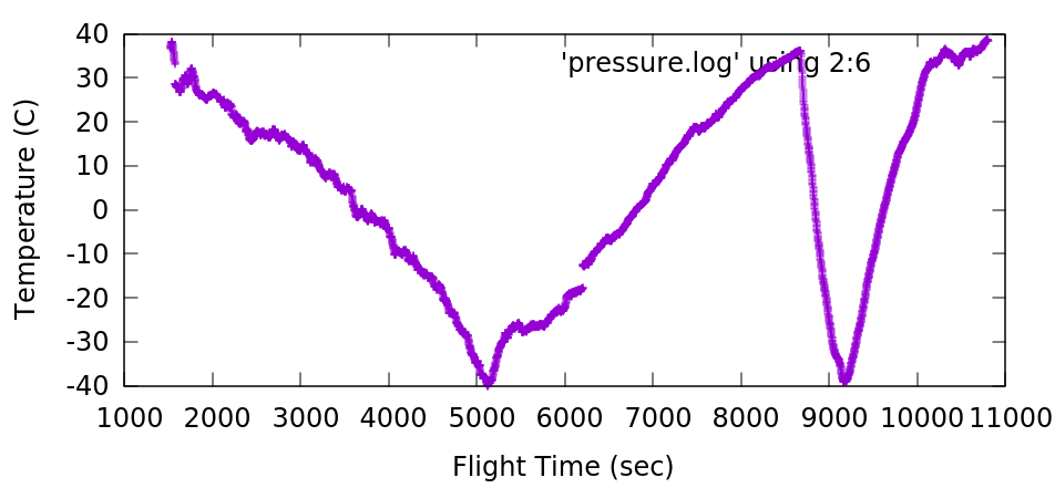
Temperature readings fall steadily from ambient ground temperature about 29.7 C to -39.9C at 16:20:19 UTC when the pressure reading was 17,568 Pa or about 40,300 ft calculated altitude. It then rises again to 36.3 C at 17:12:10 UTC* (the payload is in the sun and there’s less convective cooling with less air). That’s roughly the peak altitude. Then the temperature falls more steeply as the payload descends into cold (-40C) air, and then warms near ground altitude where the air is warmer. | |||
[[File:Sb7T_ftime.png]] | |||
'''Illumination''' | |||
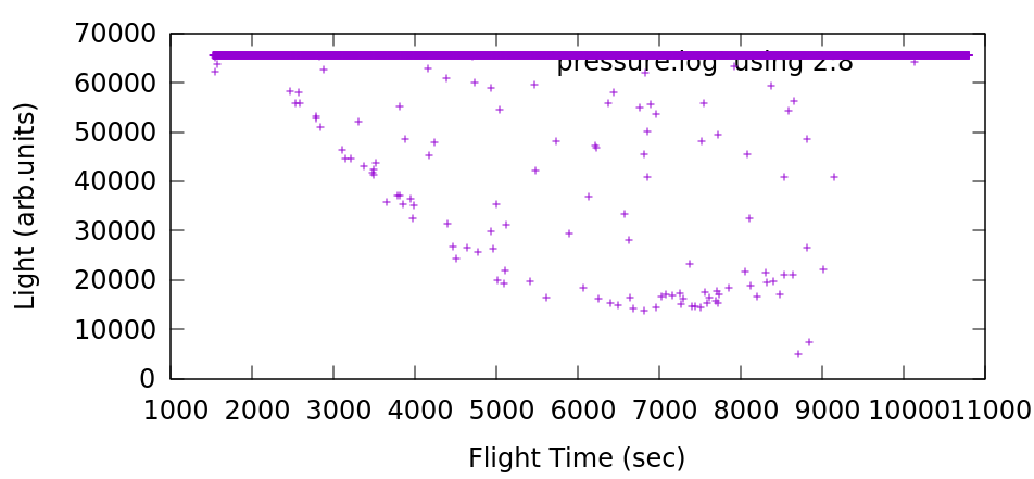
Direct sunlight maxes out the illumination sensor (at 65,535 bits) and most of the data is thus this value. But some data points are lower, possibly measurements taken randomly in the shade of the nylon strap as the payload rotated. These would be measurements of the sky brightness not including direct sunlight, and they show a trend. They begin hear 60,000 and fall steadily to 15,000, i.e the sky transitions from bright to relatively dark. Illumination includes light scattered from the balloon and rigging. Large deviations from the max value (i.e. dark measurements) stop abruptly near the peak altitude. I’ll guess the payload was spinning too fast in descent to acquire a complete measurement in the shade. | |||
[[File:Sb7Lux_ftime.png]] | |||
'''Blueishness''' | |||
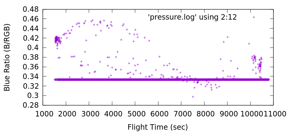
I calculated blue saturation by taking the Blue/RBG ratio in the RGB sensor data. Again, most of the time the sensor is maxed out by direct sunlight, setting the Blue/Red ratio to 1.0. However in the shade the measurement is meaningful. The sky illumination becomes more blue for about 2000 seconds (35-40 minutes) and then becomes less blue. At the highest altitudes the illumination is actually slightly reddish (the latex balloon color?). | |||
[[File:Sb7Blue_fltime.png]] | |||
'''Delay between measurements''' | |||
In principle all measurements should take the same amount of time, although some scatter is expected from the script swapping between fast accelerometer data (about 10 seconds worth) and environmental sensor data (measured every few seconds). The Raspberry Pi Zero was also tasked with photographing another payload every 60 seconds or so, an operation that could hog the CPU or the microSD card momentarily. These should be regular, consistent delays throughout the flight. | |||
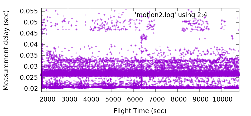
The timestamp differential between measurements is largely binomial; the measurements are either 21 or 27ms apart although there's significant scatter even up to 55ms. | |||
The '''glitch''' is visible in this data as well, as a statistical change in the measurement delay times: the fastest measurements (20.1-20.5ms) became more common than they were before. This changed lasted the remaining duration of the flight. The increased measurement delays exactly at the glitch time (6336 flight seconds or 16:48:30.5 UTC) are consistent with the script running while boot processes are still momentarily running after a reboot. | |||
[[File:Sb7Delay_ftime.png]] | |||
=Accelerometer Data= | |||
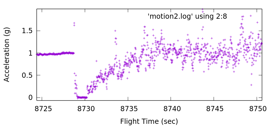
The ascent phase was gentle with excursions of +/- 0.2g. There's no indication of an acceleration anomaly just prior to the glitch. The balloon pop occurs near 17:12:19* UTC where the total acceleration suddenly drops from 1.0g to below 0.1g for several seconds. Terminal velocity is approached very quickly as within 10 seconds the payload registers an average of about 1.0g again. | |||
[[File:Sb7Accelg_pop_ftime.png]] | |||
Minimum Pressure: 1685Pa at 17:11:56.1* UTC. | |||
Peak Temperature: 36.25C at 17:12:10.7* UTC. | |||
Last '~1G' Data: 1.07g at 17:12:18.5* UTC. | |||
First 'Zero-G' Data: 0.1g at 17:12:19.1 UTC.** | |||
*Timestamps after 164737 are slow by 30 minutes due to a glitch (see glitch discussion above). 171200 corresponds to 17:42 UTC. | |||
**Note the the sequence is 1.07, 1.75, 1.70, -0.06, 0.10g in a span of 0.6 seconds. | |||
=System Logs= | |||
'''Useful Links''' | '''Useful Links''' | ||
Latest revision as of 14:49, 19 May 2018
Flight Summary
| Date of launch: | Saturday, April 14, 2018 |
|---|---|
| Time of launch: | 11:08 |
| Time of landing: | 14:30 |
| Time of recovery: | ~17:15 |
| Flight duration: | 3:22:00 |
| Peak recorded altitude: | TBD |
| Location of launch: | Strasburg VA, (38 59'48.77"N 78 21'03.27"W) |
| Location of landing: | Manchester MD, (39 40'33.6"N 76 44'03.9"W) |
| Distance (launch to landing): | 98.3 mi, (158.2 km) |
| Balloon type: | 1500 g Kaymont |
| Payload weight: | TBD |
| Balloon lift: | TBD |
| Net lift: | TBD |
Project Description & Status
SpaceBlimp 7 was designed as a community project driven by independent specialists from DC (Nancy C. Wolfson-Project Manager), Maryland, and members from HacDC (Enrique Cobas-Technical Manager), Rockville Makerspace (Samarth C. & David R. DeLalio- Technical Manager), and Unallocated Hackerspace. Spaceblimp 7 is an educational and exploratory stratospheric balloon project that lofts various payloads to near-space (about 100,000ft). The team is dedicated to experimenting with new technologies that will make near space activities less expensive and more broadly accessible. From electronics to mechanical design to physics, the interconnectedness of disciplines teaches a lesson in engineering teamwork and collaboration.
The project has Technical, logistical and Educational goals which are described below. Spaceblimp 7 looks to add new components that weren’t part of HacDC’s previous six Spaceblimp launches. By forming a partnership with several other area makerspaces, volunteers, hackers and educators we are expanding our team and pooling resources. By expanding the project we aim to increase its visibility and benefit all the organizations involved as well as an increase fund-raising opportunities to help sustain all the partners/organizations and the project Spaceblimp in the long-term. This will also expose high school students to educational and technical resources outside of the school environment as well as giving all the participants the opportunity to share skills and interests to work together and learn from one another to achieve shared goals. Local area hackers and space enthusiasts will also benefit by being able to actively participate and develop skills in the design and launch of the payloads.
Local area hackers, space enthusiasts, and community members have come together to share and learn new skills in the design, construction, and launch of the project.The sixth launch, Spaceblimp 6, reached 104,000ft. Spaceblimp 7 is being done in collaboration with Rockville Makerspace [1] and Unallocated Space [2].
COMING SOON: -Technical, Logistical, Educational and Outreach Results. -The Story Behind the Spaceblimp 7 -Photo Galery
Project Goals
Baseline technical goals are the safe and successful launch, tracking and recovery of a stratospheric balloon and its payloads. These goals involve exploration of concepts of buoyancy, basic electronics and energy storage, triangulation and timekeeping, radio propagation, weather prediction, FAA regulations and stratospheric environment conditions. In addition to these baseline goals, the project will welcome additional technical goals from volunteers and students primarily in the form of payload experiments suggested, designed and built by them. Spaceblimp will encourage use of CubeSat geometry payloads to give students experience with the CubeSat design constraints and to foster discussion with future other CubeSat missions.
The educational objective is primarily to provide an engaging, multi-day hands-on educational experience for students and volunteers heavily focused on STEM. Students will be engaged in a hands-on lesson by disassembling, reassembling and testing the basic tracking module components (GPS, radios) and other payloads. The nature of the balloon flight will naturally lead to discussion of scientific subjects like buoyancy, atmospheric composition and density, radio propagation, weather prediction and technical topics like power consumption and energy storage. Students will have first-hand exposure to a team working environment with delegation of responsibilities and the necessary communication and coordination. Critically, students will be allowed to suggest, design and build their own balloon payloads to be launched into near-space. This kind of self-directed educational approach uses students own natural curiosity and motivation to increase engagement and their sense of ownership of the resulting project.
Flight Summary
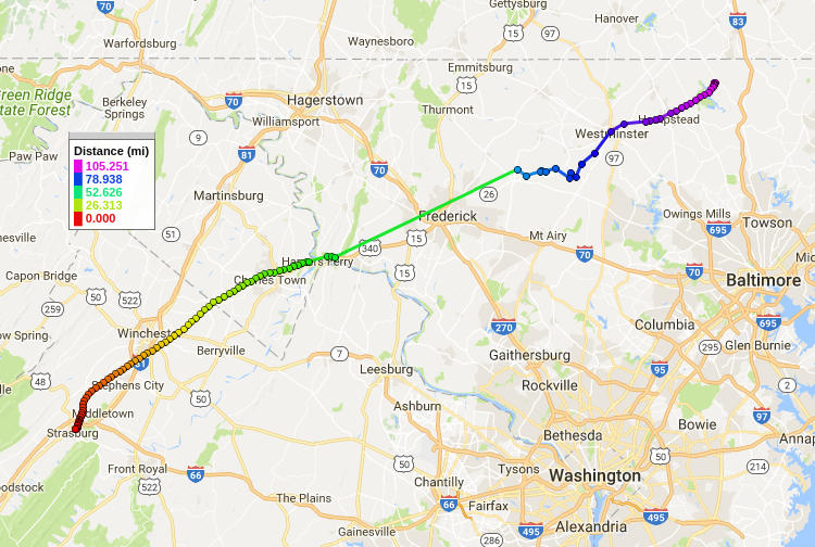
After two weather-related postponements, launch took place on Saturday April 14, 2018, at Strasburg VA. Spaceblimp 7 was launched from Shopping Center Drive in Strasburg, VA and was recovered just outside of Pretty Boy Reservoir in Manchester, MD, just south of the Pennsylvania border. As indicated by the recorded track above, GPS coodinates were lost near Harper's Ferry, WV at an altitude about 30,000ft and regained during the descent. At the moment the cause for both GPS receivers to lose their lock at roughly the same time is unexplained. Possibilities include interference from the Raspberry Pi Power Supply DC-DC Converter or jet stream turbulence rocking the payload, causing loss of line-of-sight to GPS satellites. However, the GPS lock was reliable at first, and was regained during the more turbulent descent phase.
Logistics
Project logistics include those necessary to achieve the technical goals, but also networking of area makerspaces and volunteers, outreach to local governments, funding sources and potential sponsors, coordination of project documentation and public exhibition of the project. This may include informational booths at relevant area events, compilation of video and publication of a project wiki. All new partners (including students) will be able to add or edit our project plan and proposed new topics for the meeting’s agenda.
Points of Contact: HacDC: Enrique C, Technical Manager and Funding POC, [email protected] HacDC: Nancy W, Project, Logistics and Student Outreach Manager Rockville RSC: Sam C, Technical Manager Rockville RSC: David D, Logistics and Outreach Manager Unallocated Space: Buddy, Technical and Logistics Manager
Environmental Data
A nearly-complete record of sensor measurements was obtained from the Raspberry Pi Pimoroni Enviro PHAT sensor board. These divided into two data logs, one for pressure, temperature, illumination, illumination color and one for 3-axis acceleration and compass heading. The former acquired data several times per minute while the latter was acquired at about 40Hz. These were acquired and analyzed using Python scripts and plotted in gnuplot.
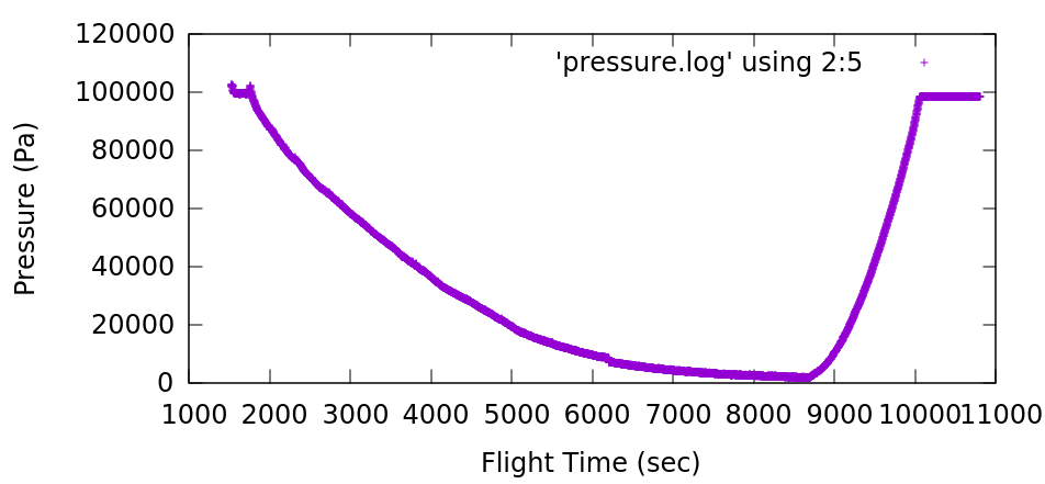
The pressure drops as expected from atmospheric (101kPa) to 1.68kPa. The minmium pressure recorded corresponds approximately to 94,000ft altitude according to some online calculators. Since we lack a GPS log of altitude at high altitudes, this is an important estimate. However, the sensor component on the Enviro PHAT is only rated down to 30kPa and readings far below this range may be untrustworthy. We may perform additional tests of the EnviroPHAT board in a vacuum chamber to establish a calibration. In addition the timestamp for the minimum pressure (171156 UTC) may be incorrect due to an unexplained glitch (see below).
For all plots below, Flight Time (sec) was obtained by dividing evenly among all timestamps between 15:00:00 and 18:00:00 UTC. However, 18:00 UTC should actually read 18:30 UTC (see glitch below). In addition, this method hides the uneven distribution of data collection especially in accelerometer data. In reality this was acquired in bursts at 40Hz.
Glitch at 164737 UTC.
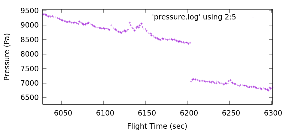
At 16:47:37.75 an unexplained glitch occurred: the timestamps in the environmental sensor log jump backwards almost 30 minutes to 161717. The pressure log drops suddenly from 8.388kPa to 7.042kPa, a drop of 1.346kPa. Note the Pi Zero doesn’t have an onboard clock so timestamps represent the running time of the script rather than the real absolute time. Extrapolating from the rate of pressure drop just before and after that point, the drop should have taken about 6 minutes. This is a reasonable delay for the Raspberry Pi to shutdown, reboot and complete a file system check and resume the measurement script. The glitch matches an unusually turbulent segment in the accelerometer data but the readings don't seem harmful (+/-0.1g at 1Hz). Far more turbulence occurred several minutes later during the ascent (+/-0.2g 1Hz), during the descent (+/-0.5g >2Hz) and during the landing (+/-2.0g) with no corresponding malfunctions.
The most turbulent part of the ascent (+/-0.2g at 1 Hz) occurred several minutes later and during the decent
Temperature
Temperature readings fall steadily from ambient ground temperature about 29.7 C to -39.9C at 16:20:19 UTC when the pressure reading was 17,568 Pa or about 40,300 ft calculated altitude. It then rises again to 36.3 C at 17:12:10 UTC* (the payload is in the sun and there’s less convective cooling with less air). That’s roughly the peak altitude. Then the temperature falls more steeply as the payload descends into cold (-40C) air, and then warms near ground altitude where the air is warmer.
Illumination
Direct sunlight maxes out the illumination sensor (at 65,535 bits) and most of the data is thus this value. But some data points are lower, possibly measurements taken randomly in the shade of the nylon strap as the payload rotated. These would be measurements of the sky brightness not including direct sunlight, and they show a trend. They begin hear 60,000 and fall steadily to 15,000, i.e the sky transitions from bright to relatively dark. Illumination includes light scattered from the balloon and rigging. Large deviations from the max value (i.e. dark measurements) stop abruptly near the peak altitude. I’ll guess the payload was spinning too fast in descent to acquire a complete measurement in the shade.
Blueishness
I calculated blue saturation by taking the Blue/RBG ratio in the RGB sensor data. Again, most of the time the sensor is maxed out by direct sunlight, setting the Blue/Red ratio to 1.0. However in the shade the measurement is meaningful. The sky illumination becomes more blue for about 2000 seconds (35-40 minutes) and then becomes less blue. At the highest altitudes the illumination is actually slightly reddish (the latex balloon color?).
Delay between measurements
In principle all measurements should take the same amount of time, although some scatter is expected from the script swapping between fast accelerometer data (about 10 seconds worth) and environmental sensor data (measured every few seconds). The Raspberry Pi Zero was also tasked with photographing another payload every 60 seconds or so, an operation that could hog the CPU or the microSD card momentarily. These should be regular, consistent delays throughout the flight.
The timestamp differential between measurements is largely binomial; the measurements are either 21 or 27ms apart although there's significant scatter even up to 55ms.
The glitch is visible in this data as well, as a statistical change in the measurement delay times: the fastest measurements (20.1-20.5ms) became more common than they were before. This changed lasted the remaining duration of the flight. The increased measurement delays exactly at the glitch time (6336 flight seconds or 16:48:30.5 UTC) are consistent with the script running while boot processes are still momentarily running after a reboot.
Accelerometer Data
The ascent phase was gentle with excursions of +/- 0.2g. There's no indication of an acceleration anomaly just prior to the glitch. The balloon pop occurs near 17:12:19* UTC where the total acceleration suddenly drops from 1.0g to below 0.1g for several seconds. Terminal velocity is approached very quickly as within 10 seconds the payload registers an average of about 1.0g again.
Minimum Pressure: 1685Pa at 17:11:56.1* UTC.
Peak Temperature: 36.25C at 17:12:10.7* UTC.
Last '~1G' Data: 1.07g at 17:12:18.5* UTC.
First 'Zero-G' Data: 0.1g at 17:12:19.1 UTC.**
- Timestamps after 164737 are slow by 30 minutes due to a glitch (see glitch discussion above). 171200 corresponds to 17:42 UTC.
- Note the the sequence is 1.07, 1.75, 1.70, -0.06, 0.10g in a span of 0.6 seconds.
System Logs
Useful Links Working documents on Google Drive: [3]
| [email protected] |
| Subscribe to the Spaceblimp email list |

